The European Space Agency (ESA) has launched its pioneering Biomass satellite into space as part of its major breakthrough for climate science and environmental monitoring.
This is the start of a mission to chart the world’s forests in 3D and provide the most precise measures of global forest carbon stock ever recorded from space.
Space Umbrella is The Key to Peering Beneath Forest Canopies
ESA Launches ‘Space Umbrella’ to Fight Climate Change: What Does
ESA
Hailing from Kourou, French Guiana, the launch took place at around 11:15 CEST. The biomass satellite was contained inside the Vega-C rocket.
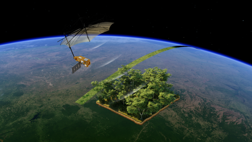
Once in space, the satellite will unfurl a huge, space umbrella-shaped radar antenna, designed by US defense contractor L3 Harris. Because of its complexity, it will take nine days to complete the deployment.
The radar instrument, a P-band synthetic aperture radar, is the world’s first to be deployed into space. Developed by Airbus, the radar has long wavelengths that can penetrate forest canopies to gauge the woody biomass underneath, where most of the carbon in a forest resides.
The Next Web tells us to think of it as an MRI for the forests on Earth — imaging from space to reveal data buried under dense leaves.
Read more:
Fog Harvesting: Scientists Develop New Tech That Can Turn Fog into Water For Drought-Stricken Areas
Unveiling Earth’s Biomass in Unprecedented Detail
Biomass satellite gathers radar signals reflecting off Earth’s surface. The umbrella-shaped antenna captures these signals and bounces them back to the instrument on the satellite.
The data collected is then processed into highly detailed 3D maps of global biomass, providing information about the intricate structure of leaves, branches, and trunks.
These readings will enable scientists to monitor carbon storage and emissions with unprecedented accuracy, facilitating improved deforestation and forest regrowth monitoring.
Forests, Carbon, and the Battle Against Climate Change
The simplest explanation behind global warming is the trapping of greenhouse gases in Earth’s atmosphere. Some people confuse it with climate change, but the two terms are different from one another.
While climate change deals with rapid shifts in temperatures and weather patterns, global warming focuses more on the abnormal heating of the planet.
Forests are indeed good filters for greenhouse gases such as carbon dioxide, but when they are burned or destroyed, the global warming effects are felt much more.
By making possible the precise measurement of carbon in forests, ESA’s Biomass mission can revolutionize efforts to fight climate change. Scientists will use the mission to inform climate models, monitor progress towards emission targets, and guide policies on land use and conservation.
More Than Just Forests: Mapping Earth’s Hidden Layers
Though the satellite’s main mission centers on global biomass, its advanced radar technology is capable of doing much more. The instrument is able to create maps of subsurface geology in deserts, monitor the structure of ice sheets, and even image forest floor topography, providing a new and forceful view of Earth’s ecosystems.
Related Article:
Monster Dust Storm: Satellite Captures Insane ‘Tsunami of Sand’ Racing Across Desert in New Mexico